This assessment is mainly of the dunes and partly on the vegetation. The assessment draws on information in Semeniuk et al. (1989) in their study of the Quindalup Dunes and the coastal sector study of Searle & Semeniuk (1982).
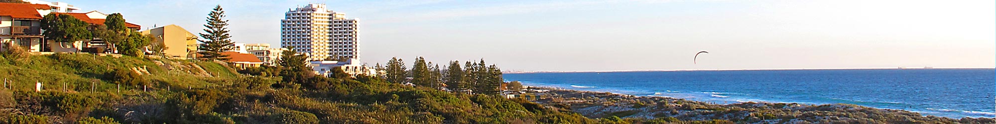
The coastal dunes between Scarborough Beach and Trigg Island belong to the Cape Bouvard to Trigg Island Sector of Searle & Semeniuk (1985) and are essentially a single set of coastal dunes comprised of shore-parallel sand ridges and depressions extending along the coastal for some 5 km. They front a terrain of former limestone cliffs (see Semeniuk & Searle 1986).
Today, as a result of storms and wind mobilisation to landward of the fore-dunes, the entire belt of coastal dunes between Scarborough Beach and Trigg Island is cliffed at its seaward edge at its contact with the storm level of the beach (see terms after Semeniuk & Johnson 1985) and, as such, there is no fore-dune – the first dune is the first sand ridge some 5 m high.
At central Scarborough Beach, where Bush Forever site 310 is located, the coastal dunes consist of a seaward shore-parallel sand ridge 5 m high, a landward linear depression, and another shore-parallel sand ridge 7 m high further landwards (Fig.1). At northern Scarborough Beach, where Bush Forever site 308 is located, the coastal dunes consist of a seaward shore-parallel sand ridge 5 m high, a landward linear depression, another shore-parallel sand ridge and its leeward linear depression, and further landwards the (most-landward) sand ridge some 12-15 m high (Fig.2), truncated by West Coast Highway.
While the largest scale of landforms consist of shore-parallel sand ridges and depressions, each some 15-25 m wide, with 2-3 ridges comprising the coastal set, at the smaller scale, the ridges themselves and the depressions are comprised of ‘chaots’ (a term by Semeniuk et al. 1989 to refer to a dune terrain of random sand hills and their intervening depressions). In fact Semeniuk et al. (1989) describe ‘chaots’ as occurring in ridge form.
Geomorphically, and in terms of coastal geoheritage (Brocx & Semeniuk 2009a), the significance of the dune belt of sand-ridge-and-linear-depressions in the Scarborough Beach and Trigg Island area is that in the central coastal and southern coastal plain area they are not that common. Further north, the wind direction changes direction (Searle & Semeniuk 1985), and coastal dune also correspondingly change form and are incomparable (Semeniuk et al. 1989).
Most of the coastal terrain in the Cape Bouvard to Trigg Island Sector consists of limestone rocky shores (Semeniuk & Johnson 1985) and where there is sand accumulation it is commonly in the form of cuspate forelands (Searle & Semeniuk 1985; Semeniuk et al. 1989) – these are incomparable geomorphically in their setting to the narrow shore-parallel belt that front former cliffed limestone terrain such as in the Scarborough Beach and Trigg Island area. The only other location where there is a linearly extensive narrow belt of shore-parallel beach ridges is at North Cottesloe. In detail, in regards to beach ridges, other coasts with beach ridges belong to cuspate foreland settings such as at Point Becher (Semeniuk & Searle 1986; Searle et al. 1988, Semeniuk et al. 1988, 1989) and, again, are incomparable geomorphically in their setting to the narrow shore-parallel belt that fronts former cliffed limestone terrain such as in the Scarborough Beach and Trigg Island area.
To assess the significance of the sand ridge system in the Scarborough Beach and Trigg Island area, from a viewpoint of their (geo)heritage value, the Geoheritage Tool-kit of Brocx & Semeniuk (2009b, 2015) can be used. This is an IUCN-endorsed technique to evaluate landforms and geology. Using the Geoheritage Tool-kit, the sand ridge belt of the Scarborough Beach and Trigg Island area is evaluated as State-wide significance because of the occurrence of a linear belt of the ridge-and-depression system outside a system of a cuspate foreland, and the occurrence of chaots as the smaller-scale landforms comprising the ridges and the depressions.
In terms of vegetation, the flora is inhabiting a distinct system of ridges and depressions and forms a distinct system of vegetation assemblages in response to the high-ground and low-ground of the topography (i.e., the ridges and depressions). Also of significance, in addition to the changes in flora according to the topography-related habitats (chaots, ridges, depressions), there is a gradient of vegetation composition in relation to distance from the strand, sea spray, and winds. In this context, even though today it is fragmented, the vegetation-and-habitat system form an important system of dunes showing an ecological gradient that is of State-wide significance.
Dr Vic Semeniuk, V&C Semeniuk Research Group, November 2016
References
Brocx M & Semeniuk V 2009a Coastal geoheritage: encompassing physical, chemical, and biological processes, shoreline landforms and other geological features in the coastal zone. Journal of the Royal Society of Western Australia 92: 243-260
Brocx M & Semeniuk V 2009b Developing a tool-kit for geoheritage and geoconservation in Western Australia. ProGeo News 2009 (1): 5-9
Brocx M & Semeniuk V 2015 Using the Geoheritage Tool-Kit to identify inter-related geological features at various scales for designating geoparks: case studies from Western Australia. In: E Errami, M Brocx & V Semeniuk (eds), From Geoheritage to Geoparks -Case Studies from Africa and Beyond. Springer, Amsterdam, 245-259
Searle D J & Semeniuk V 1985 The natural sectors of the Rottnest Shelf Coast adjoining the Swan Coastal Plain. Journal of the Royal Society of Western Australia 67: 116-136.
Searle D J, Semeniuk V & Woods P J 1988 The geomorphology, stratigraphy and Holocene history of the Rockingham – Becher plain. Journal of the Royal Society of Western Australia 70: 89-109.
Semeniuk V & Johnson D P 1982 Recent and Pleistocene beach and dune sequences, WA. Sedimentary Geology 32: 301-328.
Semeniuk V & Searle D J 1986 The Whitfords Cusp – its geomorphology, stratigraphy and age structure. Journal of the Royal Society of Western Australia 68: 29-36
Semeniuk V, Searle D J & Woods P J 1988 The sedimentology and stratigraphy of a cuspate foreland, southwestern Australia. Journal of Coastal Research 4: 551-564.
Semeniuk V, Cresswell I D & Wurm P A S 1989 The Quindalup Dunes: the regional system, physical framework and vegetation habitats. Journal of the Royal Society of Western Australia 71: 23-47.
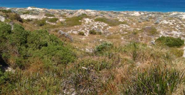
Figure 1: Sand ridges and depression with small-scale chaot dunes at Bush Forever Site 310
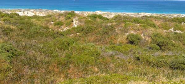
Figure 2: Vegetated sand ridges and depression fronted by a sand ridge and depression with chaot dunes at Bush Forever Site 308
Download report here.
